|
|
|
Future of Lightning
NOTE: QUOTED DIRECTLY FROM "Lightning Premier" (ask.com search result)
| Investigations Using Rockets, High-Altitude Airplanes & Spacecraft |
For many investigations, lightning must be observed from as close a vantage point as possible. One technique is to probe inside hostile thunderstorms in order to study how thunderclouds electrify, but this does not ensure close-up encounters with lightning. Close-up measurements are difficult to obtain because of the unpredictability of where and when lightning will strike. Hence, methods have been developed to create lightning discharges under somewhat controlled conditions.
Rocket-triggered lightning
research has been an important tool 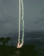 for close-up investigation.
With this technique, small sounding rockets connected to long copper wires have replaced Franklin's kite. These rockets are launched into thunderstorms with electronic sensors located near the bottom end of the wire instead of a key. When the rocket is struck by lightning, the wire is vaporized.
Data collected before and during the occurrence of lightning provide detailed information of the discharge's characteristics. Sounding rockets can also provide in-cloud measurements of thunderstorms in a challenging environment. While extensive ground based optical and electrical measurements of lightning have been made, the emphasis has been on cloud-to-ground discharges with little study of intra-cloud lightning being undertaken. This is partly due to the fact that optical measurements of in-cloud lightning are severely affected by light scattering from water droplets within the cloud. For this reason, ground-based measurements alone have not been considered an appropriate means for determining the optical characteristics of lightning as viewed from above.
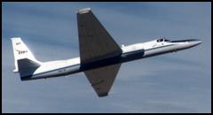 In order to determine the
requirements for making optical measurements from space, U-2 and
ER-2 high altitude airplanes have been used to study the
electrical and optical characteristics of lightning activity in
thunderstorms. Flying at an altitude of 20 km and at speeds of
200 meters per second, they are capable of flying over very large
thunderstorms.
In order to determine the
requirements for making optical measurements from space, U-2 and
ER-2 high altitude airplanes have been used to study the
electrical and optical characteristics of lightning activity in
thunderstorms. Flying at an altitude of 20 km and at speeds of
200 meters per second, they are capable of flying over very large
thunderstorms.
Much has been learned from these aircraft observations. For example, they have confirmed C. T. R. Wilson's theory that strong electric fields over the tops of thunderstorms cause conduction currents to flow to the tops of clouds. The penetrative convective cells which rise above the anvil are the most active electric regions in the storm and cause the most intense electrical stresses, as seen from high altitude aircraft.
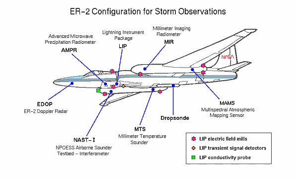
The ER-2 has a larger payload capability than its predecessor the U-2. Both have provided direct observations of severe thunderstorms and other clouds using multi-sensor payloads including lasers, infrared, visible and microwave scanners, spectrometers, and electric field antennas.
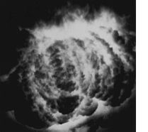 In addition, photography of
lightning from above clouds has been accomplished using an open
shutter technique. In this method, the camera is pointed toward
the thundercloud with the shutter open. In the dark nocturnal sky,
no light falls onto the film until lightning strikes. An example
of an open shutter photograph from the U-2 is shown on the left.
The illuminated storm cell depicts a convective cloud turret
approximately 11 km in height and 12 km in diameter.
In addition, photography of
lightning from above clouds has been accomplished using an open
shutter technique. In this method, the camera is pointed toward
the thundercloud with the shutter open. In the dark nocturnal sky,
no light falls onto the film until lightning strikes. An example
of an open shutter photograph from the U-2 is shown on the left.
The illuminated storm cell depicts a convective cloud turret
approximately 11 km in height and 12 km in diameter.
To complement the optical measurements from aircraft, video lightning images have been taken during a number of space shuttle flights while conducting the Mesoscale Lightning Observation Experiment (MLE). These observations have revealed many interesting lightning events.
For example, on April 28, 1990, a video image from space showed a single stratospheric luminous discharge appearing to move upward into clear night air. This was recorded on the space shuttle STS-32 mission using the payload bay TV camera.
The direction of this event
has not been firmly established, however, the stratospheric
discharge is of interest because it may provide evidence for a
theory postulated by C. T. R. Wilson 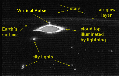 in 1925. This theory
predicted that electric fields can cause ionization at great
heights and could therefore give rise to discharges between
clouds and the upper atmosphere.
in 1925. This theory
predicted that electric fields can cause ionization at great
heights and could therefore give rise to discharges between
clouds and the upper atmosphere.
Stratospheric lightning could potentially deposit significant energy into the stratosphere, causing important chemical perturbations. In addition, these lightning events may generate strong electric fields and electromagnetic pulses which might interact with the Earth's ionosphere and magnetosphere. Finally, strong fields at high altitudes may generate runaway electrons which could then produce high energy x-rays and even gamma rays. Thus, it is possible that lightning may generate electromagnetic radiation, ranging from extremely low frequency to gamma radiation.
Researchers from the Geophysical Institute at the University of Alaska have confirmed shuttle observations by capturing images on videotape of what appear to be brief flashes of light emanating from thunderstorms into the stratosphere. These "stratospheric optical flashes", also known as "red sprites", were photographed from NASA's DC-8 Airborne Laboratory while flying at an altitude of about l2 km during a night-time mission to videotape lightning over Iowa and Kansas during June and July of 1993. Stratospheric flashes are brief, persisting for less than about a tenth of a second. They appear to be associated with intense thunderstorm activity, but are both rare and fainter than typical cloud-to-ground or intra-cloud lightning. Unlike familiar ground level lightning events that are electrical discharges confined to narrow channels, the flashes appear to cover a relatively broad horizontal extent of several miles, and to extend to altitudes of perhaps as much as 95 km, or about 60 miles.
| Lightning Detection Networks (Ground Based) |
National and regional lightning networks which use magnetic direction finders, time of arrival techniques, or VHF interferometry, provide important lightning and storm information. For a number of years, the Federal Government assisted in the financing of a national lightning data service combining independently operated systems into one network. Used primarily for operational evaluation by NOAA, it evolved into a product with substantial value for both private industry and by other Federal agencies. By 1991, recognition of the importance of lightning detection had become apparent with economically viable commercially-sponsored systems coming into existence.
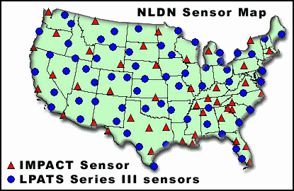
 The National Lightning
Detection Network (NLDN) which is operated by Global Atmospherics,
Inc. (GAI) in Tucson, Arizona, is a network of at least 130
magnetic direction finders which covers the entire United States.
Each direction finder determines a direction toward a detected
electromagnetic lightning discharge. The location of the
lightning discharge is determined by triangulation. Each of these
sensors is capable of detecting cloud-to-ground lightning flashes
at a distance of 400 km away and greater. Processed information
is transmitted to the Network Control Center (NCC) in the form of
a grid map showing lightning across the U.S.
The National Lightning
Detection Network (NLDN) which is operated by Global Atmospherics,
Inc. (GAI) in Tucson, Arizona, is a network of at least 130
magnetic direction finders which covers the entire United States.
Each direction finder determines a direction toward a detected
electromagnetic lightning discharge. The location of the
lightning discharge is determined by triangulation. Each of these
sensors is capable of detecting cloud-to-ground lightning flashes
at a distance of 400 km away and greater. Processed information
is transmitted to the Network Control Center (NCC) in the form of
a grid map showing lightning across the U.S.
The Atmospheric Research Systems, Inc. (ARSI) time-of-arrival (TOA) system provides 11 Lightning Position And Tracking Systems (LPATS) which cover the U.S. and extend hundreds of miles into both oceans and beyond the borders of Canada and Mexico. ARSI ground strokes lightning data includes information on latitude and longitude, date and time, polarity, and amplitude.
Recently, GDS purchased the ARSI system, and is in the process of combining the direction finding and time of arrival techniques into a single comprehensive network.
 The TOA system operates by
digitizing the waveform of a received lightning signal at each
sensor and accurately timing the peak with a resolution of up to
100 nanoseconds. The difference of arrival time at four or more
receivers is then used to calculate the location. The
geographical positions of the various sensors making up the
network are shown in the U.S. map.
The TOA system operates by
digitizing the waveform of a received lightning signal at each
sensor and accurately timing the peak with a resolution of up to
100 nanoseconds. The difference of arrival time at four or more
receivers is then used to calculate the location. The
geographical positions of the various sensors making up the
network are shown in the U.S. map.
Internationally, two very different types of lightning detection and location networks have been developed. The SAFIR two-dimensional VHF interferometer system developed by the French aerospace research organization ONERA and commercialized by Dimensions of France, is used to provide detailed information on all types of lightning activity within a relatively small area. The VLF Arrival-Time Difference (ATD) system designed and operated by the United Kingdom Meteorological Office, detects and locates lightning at very long range, but with less detection efficiency. In addition, other networks cover portions of Europe, Asia, Australia, China, and Canada.
What is Lightning? History Types Pictures Charges Future of Lightning Detection Main Page